
Hi Everyone,
Its that time of year again. Check out the latest post from Don on whats going on with the weather pattern across the US, especially the winter. His latest post shows some insight that the prospects for a colder and stormier and even wintry time wil be shifting to the Eastern US.
Background Info: As I did last season, I’m very excited to share with everyone some very good weather discussions by Donald Sutherland. He’s a weather hobbyist and enjoys long weather forecasting. His posts are very good. I’m going to update this blog several times a week with his posts from American Weather. Speaking of American Weather, this is a a great site for discussing the weather, especially for meteorologists, weather hobbyists and anyone that follows the weather. I highly recommend you checking their site. Its a site that has a wealth of great weather information.
Below will be all his updates for the month of November. As we get into December, January and February, I’ll break each into separate blogs.
******************************************************************************************************************************************
Posted Saturday, November 30 @ 10:03 PM
EPO-/PNA- pattern is highly conducive for cold weather in the Pacific Northwest. For December, that pattern accounts for more than three quarters of days on which the temperature fell to 25° or below in Seattle. Some charts to illustrate the EPO/PNA patterns and frequency of December minimum readings of 25° or below. From 1950 through 2012, there were 101 such days in December.

******************************************************************************************************************************************
Posted Saturday, November 30 @ 5:39 PM
Brief evening update…
The MEX MOS from the 11/30 12z run of the GFS illustrated the magnitude of the cold likely to impact the Pacific Northwest during the 12/3-10 timeframe. During that period, it appears likely that Seattle and Portland could see one or more low temperatures in the lower or middle 20s. One of those two cities could see a reading below 20°. Spokane will likely see one day with a high temperature in the upper teens or low 20s and a minimum temperature in the single digits.
The MEX MOS shows a high of 33° in Seattle and 18° at Spokane for 12/5. The lowest readings shown on the MEX MOS are currently 23° at Portland, 25° at Seattle, and 4° at Spokane. It should be noted that the MEX MOS does not extend through the entire period and it still gives some weight to climatology. The 11/30 12z run of the ECMWF was even colder for all three cities.
More details concerning those cities’ records and data can be found in Messages #181 and #195.
******************************************************************************************************************************************
Posted Saturday, November 30 @ 9:42 AM
December 2013 Idea (Revised):
It is rare that I wind up revising my monthly thoughts, but in this case it is necessary given the consistency of the data and now clear picture with respect to the Arctic Oscillation.
Hence, my initial December idea (#131) is not likely to verify. The partial teleconnection cases and exceptional consistency in which 2008 was highlighted as the leading teleconnection analog for December since that time argue strongly for a revision.
The final December map based on those partial cases is as follows:

Those anomalies likey reasonably represent the outcome. The notable cold coming to the Northern Plains and Pacific Northwest for the December 3-10 period should produce cold anomalies that won’t be erased. At the same time, some pieces of the cold air mass will likely bleed eastward with perhaps a strong cold shot toward mid-month. But then, as the EPO likely rises, what has been the beginning of the end of the transitional period leading to winter will likely yield to more persistent mild weather in parts of the CONUS.
In sum, Canada, the Northern and Central Plains and Pacific Northwest are likely to be colder than normal for December. The Southeast into the Middle Atlantic region will likely be warmer than normal. New England could be near normal with some below normal anomalies in northern New England. The Southwest and Southern Plains should also be warmer than normal.
******************************************************************************************************************************************
Posted Friday, November 29 @ 10:49 PM
December 16-31: What if the EPO Shifts to Predominantly Positive?
Although the second half of December is still well into the future and the EPO has been negative for 21 consecutive days, one cannot automatically assume that the EPO will remain predominantly negative throughout December. In fact, historical experience argues that the EPO would likely go positive by mid-December +/- one week. The longest stretch during which the EPO remained negative that commenced in November was 45 days. The second longest stretch was 33 consecutive days (2 occasions). The third longest stretch was 32 consecutive days.
With the AO likely to remain predominantly positive, that raises the question as to what the outcome might be should the EPO flip to positive.
Below are the composite charts for all cases December 16-31, 1981-2010 when the EPO ranged between -3 and -1 and the AO between +1 and +3 (EPO-/AO+) and when the EPO ranged between +1 and +3 and the AO between +1 and +3 (EPO+/AO+).

The composite anomalies reflect all dates, but there is some variability. If one takes a look at the four most recent years during which the EPO-/AO+ conditions were predominantly met, one finds a lot of variability.

If, however, one looks at the four most recent years during which the EPO+/AO+ criteria were predominantly met, one finds less variability.

In sum, should the EPO flip to positive and then remain predominantly positive for much or all of the second half of December, a much milder pattern could set in. For now, the ensembles are not yet suggesting such an outcome. However, historical experience argues that it is something that has to be considered and that it probably is more likely than not.
******************************************************************************************************************************************
Posted Friday, November 29 @ 4:51 PM
Upcoming Cold Period in the Pacific Northwest…
The cold period is likely to run from 12/3 through 12/10, as the guidance has extended the period. That outcome is consistent with some of the teleconnection cases and larger pool of PNA- cases that closely resemble the current pattern and possible evolution of such patterns in the past. Among the teleconnection cases showing up have been 1956, 1972, and 2008 (also in the objective analogs). All of those years featured some impressive cold in the Pacific Northwest.
The latest GFS ensemble guidance shows cold anomalies reaching 2-3 standard deviations at times.

The surface temperatures consistent with such anomalies for the December 1-10 period (1981-2010 climate reference period) are:

The daily low maximum and low minimum records for Portland, Seattle, and Spokane are below:

The last time the temperature fell below 25° in Seattle ws January 13, 2013 (24°) and the last time the temperature fell below 20° was February 26, 2011 (19°). The last time the temperature fell below 25° in Portland was just recently on November 22, 2013 (24°, 3rd lowest reading for 11/24) and the last time it fell below 20° was February 26, 2011 (18°). The last day with a high temperature of 32° or below in Seattle was January 19, 2012 (30°). In Portland, it occurred on November 24, 2010 (32°).
******************************************************************************************************************************************
Posted Thursday, November 28 @ 9:32 AM
December 8-14, 2013 Idea:
In terms of teleconnections, the same theme of an EPO-/AO+ that has dominated November seems likely to continue into at least the second week of December. Both the ensembles and teleconnection cases indicate that the cold will be focused primarily in the western half of the U.S. The strong shot of cold for the Pacific Northwest starting around 12/3 remains on target and will likely persist into at least the beginning of the second week of December. The same holds true for the Northern Plains. The outcome farther east will depend on some of the cold air coming eastward, possibly in pieces rather than all at once with a shifting trough.
The teleconnection cases and select ensemble charts are below:

I suspect that the ensembles might be rushing the cold to the east. I do believe there is a higher probability that the cold is able to bleed eastward across the northern tier. 2008 remains the leading teleconnection case at present, so I’m using it for some insight.
Overall, my thoughts are that the Pacific Northwest, Northern/Central/Southern Plains, Great Lakes area, and northern New England are likely to wind up colder than normal. The Middle Atlantic and southern New England regions will probably wind up near normal. The Southeast and Gulf Coast will probably be warmer than average. The Southwest will probably also be somewhat warmer than normal.
If the arrival of the cold air is delayed and if the area of warmth proves more expansive than what the ensembles are suggesting–and the ensembles have more expansive cold anomalies than my thinking–that could be an indication that the pattern is transitioning toward a milder winter in at least the eastern half of the U.S. Some of the other teleconnection cases that have begun showing up are December 1951, 1972, and 1990. Not all are good ENSO matches, but the combination of a strong EPO- and strong AO+ is fairly uncommon.
In the meantime, one should be thankful that the long-range is never locked in stone. Uncertainty can provide hope for a nicer outcome. Happy Thanksgiving to all and happy Hanukkah to all of AmericanWx’s Jewish members.
******************************************************************************************************************************************
Posted Wednesday, November 27 @ 12:28 PM
Brief afternoon thoughts: Themes of 2008 abound…
1. The 12z GFS extended the cold period in the Pacific Northwest. In 2008, there was an approximately two-week long period of cold in that area (#165).In Seattle, 6 days had highs of 32° or less. The lowest high temperature was 26° on 12/20 (3rd coldest high for the date).
2. The December 3-6 period still looks unseasonably cold in the Pacific Northwest, but the cold lasts longer. Another shot of cold shows up on the GFS toward the end of its forecasting range.
3. The GFS ensembles now show cold anomalies of 2-3 standard deviations from normal (relevant table for the 12/1-10 period is shown in #181).
4. The MOS guidance, which runs only through 12/5 and factors in climatology, shows lowest temperatures for Seattle, Spokane, and Portland as 28°, 14°, and 28° respectively. The 12z GFS shows lowest temperatures through 12/6 of 15° in Seattle, 7° in Spokane, and 15° in Portland.
All said, confidence that the Pacific Northwest is poised for a period of cold, possibly severe relative to climatology for a time, and possibly one that could last at least a week or longer is growing.
******************************************************************************************************************************************
Posted Wednesday, November 27 @ 9:37 AM
This morning, the Arctic Oscillation stood at +1.955. That follows a brief period of blocking in which the stage was set for what will be two significant intrusions of Arctic air in the eastern half of North America. The first was the 11/24-25 Arctic blast that set numerous daily low maximum records on the 24th, as well as some daily record minimum readings, particularly on the 25th. The next shot will be pushing into the east today and will produce another period of below normal to much below normal readings during the 11/28-30 period.
One of the scenarios discussed earlier in this thread was that if the AO goes positive and remains predominantly positive is that December 2008 provided a reasonable case for the outcome (#150). December 2008 featured some notable cold in the Pacific Northwest during a two-week period and such cold shows up on the operational and ensemble guidance (#181).
With today’s teleconnection data and ensemble forecasts, 2008 remains a leading case. In fact, the CFSv2 forecasts are remarkably similar both to the December 2008 monthly anomalies and the pattern progression, with only some minor timing differences. Below are the CFSv2 Week 2-4 forecasts and corresponding date in 2008 that seems to match quite well. Afterward, the December 2013 CFSv2 monthly forecast is compared with December 2008.


******************************************************************************************************************************************
Posted Wednesday, November 27 @ 12:31 AM
Odds Growing of a Strong Cold Shot in the Pacific Northwest for December 3-6, 2013:
The PNA is forecast to fall below -1 in early December, even as the EPO remains strongly negative. Such a pattern can be conducive to strong cold shots for the Pacific Northwest.
The composite temperature anomalies for all December dates (1981-2010) when the PNA was -1 or lower is below:

The GFS ensembles indicate 850 mb temperatures that could run approximately 2 standard deviations below normal in parts of the Pacific Northwest. Charts showing the ensemble forecast, temperatures associated with such standardized departures, and daily record low maximum and minimum temperatures are below:

Finally, the 11/27/2013 0z run of the GFS forecasts some extreme cold for the Pacific Northwest with the lowest temperatures forecast as follows:
Portland: -10.7°C (13°F)
Seattle: -10.5°C (13°F)
Spokane: -14.0°C (7°F)
In sum, it appears likely that Seattle and Portland could see one or more low temperatures in the lower or middle 20s. One of those two cities could see a reading below 20°. Spokane will likely see one day with a high temperature in the upper teens or low 20s and a minimum temperature in the single digits.
******************************************************************************************************************************************
Posted Monday, November 25 @ 10:26 PM
My Winter 2013-14 Idea:
In the wake of one of the strongest November cold shots in years, it might be tempting for one to embrace winters along the lines of 1976-77, 2000-01, and 2002-03. With the Arctic Oscillation (AO) having gone negative after one of the strongest November positive regimes, one might be anticipating the development of a blocky winter. With the East Pacific Oscillation (EPO) having brought a series of cold shots to the U.S. and southern Canada, in spite of the strongly positive AO, one might be tempted to believe that the AO won’t matter this winter.
However, strong November cold shots do not necessarily assure a cold winter in the affected areas. In fact, if the first week of December turns warm, that’s often an indication that a milder winter lies ahead. When it comes to the AO, both the Snow Advance Index (SAI) and the new October Pattern Index (OPI) are in agreement that the AO will very likely be predominantly positive for the December-February timeframe. At the same time, the EPO is likely to remain predominantly negative to neutral.
What happens during EPO-/AO+ winters might provide insight into winter 2013-14. While there is variation, the placement of the coldest anomalies (adjusted to take into consideration a share of the warming that has occurred since 1970—roughly 0.6°C per decade in the CONUS for the December-February period) suggest that December has the best chance to have the most widespread cold anomalies. Afterward, the coldest anomalies tend to lift northward, as the AO+ plays a stronger role. Below are the charts for the placement of the coldest anomalies from the analog cases alongside the latest monthly ensemble forecasts from the CFSv2. The charts are strictly aimed at showing the migration of the coldest anomalies, not the placement of warm anomalies or magnitude of the temperature anomalies. They bear some similarity to the latest CFSv2 forecasts. In short, those forecasts appear to be reasonable relative to EPO-/AO+ cases.

With the winter Pacific Decadal Oscillation (PDO) likely to average negative, albeit not as negative as last winter, along with neutral ENSO conditions, a predominantly neutral to negative Pacific North America (PNA) pattern is likely to predominate. Such a pattern favors the development of southeast ridging in the absence of a negative Arctic Oscillation.
Overall, that would likely translate into much of Canada winding up colder than normal and a large portion of the CONUS winding up milder than normal for the December-February period

Taking into consideration the likely state of ENSO and the teleconnections, as well as some of the modeled seasonal forecasts, I expect December-February to turn out as follows:
Alaska: Cold East/Warm West
Canada: Generally colder than normal except for southern Canada. Toronto and Montreal will likely wind up near normal to somewhat warmer than normal. Ottawa and Quebec City will likely be somewhat cooler than normal to near normal.
CONUS: Generally somewhat warmer than normal across the nation. The Southeast/Gulf Coast will likely have the warmest anomalies relative to normal. The Northern Plains could wind up somewhat cooler than normal.
******************************************************************************************************************************************
Posted Monday, November 25 @ 9:07 AM
Morning thoughts…
1. The CFSv2 December 2013 forecast continues to closely resemble the 12/7-8/1989 anomalies (#131). This outcome would be consistent with the idea of a weak southeast ridge for at least a portion of December.
2. The guidance continues to insist on an EPO- for the foreseeable future. The brief PNA+ pattern that is currently underway is forecast to revert back to a PNA- in coming days. Very likely the PNA will wind up negative to neutral, on average, for the winter given the PDO-. The ensembles are split in the extended range as to whether the AO will stay positive once it rises from current negative levels or whether a brief positive period would be followed by a renewed round of blocking. While at least part of December could see intervals of blocking, odds still favor a general AO+ for the winter as a whole. Hence, the recent return of AO+ for the extended range on the ensembles isn’t entirely surprising.
3. Near the end of their forecast range, the GFS ensembles hint at another progression of an area of cold that would develop in northwestern Canada and then come south and eastward, similar to what happened with the now departing cold air mass that produced widespread record low maximum readings from the eastern Ohio Valley across the northern Mid-Atlantic region and into New England.
In terms of extremes, yesterday saw Mt. Washington set a record low daily maximum temperature (-4° around midnight) and minimum temperature (-15°), even as the wind was sometimes sustained at more than 100 mph. This morning saw Mt. Washington set another record low temperature of -16°.
******************************************************************************************************************************************
Posted Sunday, November 24 @ 5:02 PM
Record Daily Low Maximum Temperatures from 11/24:
Baltimore: 32° (tied record set in 1880)
Bridgeport: 31° (old record 35°, 2000)
Danbury: 28° (old record: 32°, 1970)
Islip: 31° (old record: 34°, 1989)
New York City:
…Central Park: 30° (tied record set in 1880)
…JFK: 32° (old record: 35°, 1970)
…LGA: 32° (old record: 34°, 1956)
Newark: 31° (old record: 34°, 1938)
Philadelphia: 32° (old record: 34°, 1956)
Trenton: 31° (old record: 37°, 2000)
White Plains: 29° (old record: 31°, 1972)
******************************************************************************************************************************************
Posted Saturday, November 23 @ 3:08 PM
December 2013 Idea:
Given the evolution of the major teleconnection indices, which offer a quick representation of the pattern (they are not a substitute to the pattern but help provide insight into it) and historic experience concerning strong cold shots in November, it appears likely that much of North America will feature a colder than normal December. Colder than normal readings are likely in such cities as Baltimore, Boston, Chicago, Cleveland, Detroit, Montreal, New York City, Ottawa, Philadelphia, Providence, Richmond, Quebec City, Toronto, and Washington, DC.
The most recent run of the CFSv2 shows cold anomalies that are remarkably similar to those that occurred in the December 7-8, 1989 period. The partial teleconnection cases, which are used for observing trends, show widespread cold.

In addition, since 1950, there were 7 years that featured cold shots during the 11/20-30 period of similar magnitude to what is likely to occur over the next week and then a cold December 1-10 period. All 7 years featured cold in the areas that saw a cold 11/20-30 period. The composite temperature anomalies are shown below.

Given the above data, historical cases, and extended range of the ensembles. My guess is that the eastern half of the U.S. with the exception of the Southeast and Gulf States is likely to be colder than normal for December. The Southeast and Gulf region will probably wind up with near normal readings. The western third of the U.S., including the Pacific Northwest could be warmer than normal. Most of Canada except for western/northwestern Canada will likely be colder than normal. The excepted areas could be warmer than normal. Alaska should wind up warmer than normal.
Even as the pattern could shift to a milder one toward mid-month if some of the ensemble guidance is correct, the cold anomalies from the first half of the month are likely to be too great to overcome in the areas noted above as likely to be colder than normal.
******************************************************************************************************************************************
Posted Saturday, November 23 @ 8:43 AM
Some quick morning thoughts…
1. It appears that the MET (NAM) MOS is performing better than the MAV (GFS) MOS this morning. The big question concerns this afternoon. If that trend holds up, then it’s possible that the colder NAM’s MOS might be a little closer to tomorrow’s high temperatures in the East.
2. For the 3rd out of the last 4 days, the partial teleconnection analogs suggest cold in a large part of the East for December. The look on that map is fairly similar to the latest CFSv2 forecast for December.
******************************************************************************************************************************************
Posted Friday, November 22 @ 9:03 AM
Morning Thoughts…
1. The latest data continues to indicate that the impressive shot of cold air could challenge record daily maximum low readings for November 24 and possibly approach or surpass the lowest daily maximum readings in November since 2000 in parts of the Mid-Atlantic and New England areas.

2. The partial teleconnection cases rolled forward indicate a cold December for the 2nd of the past 3 days. The look this morning is a thing of beauty for cold weather lovers:

3. Historical experience for years with the kind of strong cold shots that occurred in late November and is modeled for the start of December have typically seen the affected region wind up colder than normal in December.
All said, IMO, odds have shifted toward a colder December in large parts of the East, Ohio Valley, and Great Lakes region (historical experience + increasing tendency for cold on the partial teleconnection cases). Early month cold anomalies may be difficult to completely erase if or when a pattern shift to milder takes place.
******************************************************************************************************************************************
Posted Thursday, November 21 @ 11:26 PM
Evening thoughts…
1. The severe November cold shot remains on track for the 11/24-26 period as per the 11/22 0z run of the GFS.
2. Looking ahead to December, this morning, I noted that the partial teleconnection cases returned to a milder look (#102), though the month will likely start off on a cold note. Those cases had some similarities to the CFSv2, but featured more widespread warm anomalies. This evening, I factored in ENSO.
The map from this evening alongside the latest CFSv2 December forecast is below.

3. There remains uncertainty as to how much blocking might occur in December, even if the AO is predominantly positive. Neither idea is cast in stone just yet, but this is a timeframe where the ideas have started to show some skill.
******************************************************************************************************************************************
Posted Thursday, November 21 @ 10:59 AM
Severe November Cold Shot…
For some time, the November 22-30 period has looked colder than normal in the eastern U.S. (#40) and the ensemble guidance has suggested an unusually strong shot of cold at some point during the timeframe (#87). As the event has drawn nearer, the cold shot appears even more impressive than earlier modeled. The cold air that will blast into the region later Saturday appears likely to produce near record low maximum readings on Sunday (11/24) and near record low temperatures on Monday morning (11/25). A few areas could see new records.
The GFS ensemble mean shows 850 mb temperature anomalies of 2.0-2.5 standard deviations across an expansive area of the East for 11/25 0z.

That air mass appears only slightly warmer than the record cold air mass of 1938 (850 mb anomalies are below).

In terms of outcomes, the below charts show the kind of temperatures that are associated with the above-mentioned standardized anomalies, MOS and GFS operational forecasts, and records for Boston, New York City, Philadelphia, and Washington, DC.

In terms of outcomes, it appears possible that Boston and New York City could experience a high temperature at or below 32° on Sunday. Philadelphia also has a shot at approaching its record low maximum temperature on Sunday. All of the above cities will likely see low temperatures in the low 20s on Monday. Many outlying areas will see low temperatures in the teens. The possibility of a temperature below 20°, particularly in Boston or Philadelphia exists. Philadelphia has perhaps the best shot at approaching or reaching its daily record low temperature for Monday.
******************************************************************************************************************************************
Posted Thursday, November 21 @ 8:50 AM
Morning thoughts…
1. The latest data led to the partial teleconnection cases returning to the generally mild look they had maintained over the past two weeks (mild anomalies across much of the CONUS/cold readings across a large part of Canada/a fairly large area of cold anomalies in Europe), with yesterday having been an exception. December 2008 was the best fit. The possible variable responsible is that the ensemble guidance has again returned to a state where many members forecast a return to PNA- conditions after a brief period of PNA+.
2. The latest monthly CFSv2 forecast for December is warm in the East and across much of the southern tier of the U.S. It is cold throughout much of Canada. That’s not dissimilar from the partial teleconnection cases, though those cases show more widespread warm anomalies than the CFSv2 does. The CFSv2 is now moving into a timeframe where its monthly forecasts have shown some skill.
3. The potential transitional period that has shown up repeatedly (yesterday being an exception) was the December 5-10 timeframe. The latest CFSv2 Week 4 forecast for the December 12-16 period shows warmth across the eastern half of the U.S., cold in the western third, and cold across much of Canada into Alaska.
******************************************************************************************************************************************
Posted Wednesday, November 20 @ 9:12 PM
December 1-7, 2013 Thoughts…
The generally cold pattern now underway and likely to be reinforced from time to time with fresh shots of unseasonably cold air is likely to continue during the first week in December. Both the ENSO-teleconnection cases and objective analogs from the GFS ensembles centered around 12/1 are in good agreement that the eastern third to half of the U.S. and a large part of Canada will be colder than normal.

It remains plausible that at least one of the cold shots during that timeframe, perhaps much like the upcoming one Sunday-Tuesday of next week could feature low temperatures 1-2 standard deviations below normal. That would potentially bring readings into the teens or low 20s for at least some of the big cities from Philadelphia to Boston. Cold shots that have produced teens or colder during the first week of December in that region have often signaled a cold month, as the cold anomalies have proved to great to overcome once the pattern shifted.
One would look for indications of perhaps a cold December on the partial teleconnection cases. For nearly two weeks, they have been very consistent with the idea of a transition to a milder pattern and overall warm anomalies in a large part of CONUS, and cold anomalies across much of Canada. However, the latest data has produced the first colder solution in a while. It remains to be seen whether that is a temporary departure or perhaps an indication that December could be cold. For now, uncertainty about December has increased. My December thoughts will likely be posted early next week, just prior to the Thanksgiving Day holiday. The winter thoughts will be posted around or perhaps just after Thanksgiving Day.
Finally, looking ahead to the winter as a whole, the ensembles have backed off the prospect of a sustained period of blocking in the extended range. Instead, after a brief period, the AO is forecast to revert back to positive or strongly positive values. This outcome is perhaps another signal that the winter will likely feature a predominant AO+ regime. Having said that, there is some possibility that as the QBO approaches 0, possibly in February or March, blocking could become somewhat more frequent.
Some discussion has focused on the idea that the EPO could bail out the CONUS from a warm outcome were the AO to become predominantly positive. However, it should be noted that when the AO is strongly positive, the EPO typically is positive and almost always not strongly negative. For example, for the December 1981-2010 base period, the EPO was positive in 57% of the cases when the AO was +0.5 or above. During those AO cases, the EPO was above -1.0 82% of the time. Hence, while the EPO has frequently gone strongly negative (about 40% of the past 30 days have seen the EPO at or below -1.0), the EPO could be more neutral to weakly negative than strongly negative in December.
For now, the cold close to November in parts of the CONUS will likely extend into at least the first week in December.
******************************************************************************************************************************************
Posted Wednesday, November 20 @ 11:23 AM
December 1-7, 2013 Thoughts…
The generally cold pattern now underway and likely to be reinforced from time to time with fresh shots of unseasonably cold air is likely to continue during the first week in December. Both the ENSO-teleconnection cases and objective analogs from the GFS ensembles centered around 12/1 are in good agreement that the eastern third to half of the U.S. and a large part of Canada will be colder than normal.
It remains plausible that at least one of the cold shots during that timeframe, perhaps much like the upcoming one Sunday-Tuesday of next week could feature low temperatures 1-2 standard deviations below normal. That would potentially bring readings into the teens or low 20s for at least some of the big cities from Philadelphia to Boston. Cold shots that have produced teens or colder during the first week of December in that region have often signaled a cold month, as the cold anomalies have proved to great to overcome once the pattern shifted.
One would look for indications of perhaps a cold December on the partial teleconnection cases. For nearly two weeks, they have been very consistent with the idea of a transition to a milder pattern and overall warm anomalies in a large part of CONUS, and cold anomalies across much of Canada. However, the latest data has produced the first colder solution in a while. It remains to be seen whether that is a temporary departure or perhaps an indication that December could be cold. For now, uncertainty about December has increased. My December thoughts will likely be posted early next week, just prior to the Thanksgiving Day holiday. The winter thoughts will be posted around or perhaps just after Thanksgiving Day.
Finally, looking ahead to the winter as a whole, the ensembles have backed off the prospect of a sustained period of blocking in the extended range. Instead, after a brief period, the AO is forecast to revert back to positive or strongly positive values. This outcome is perhaps another signal that the winter will likely feature a predominant AO+ regime. Having said that, there is some possibility that as the QBO approaches 0, possibly in February or March, blocking could become somewhat more frequent.
Some discussion has focused on the idea that the EPO could bail out the CONUS from a warm outcome were the AO to become predominantly positive. However, it should be noted that when the AO is strongly positive, the EPO typically is positive and almost always not strongly negative. For example, for the December 1981-2010 base period, the EPO was positive in 57% of the cases when the AO was +0.5 or above. During those AO cases, the EPO was above -1.0 82% of the time. Hence, while the EPO has frequently gone strongly negative (about 40% of the past 30 days have seen the EPO at or below -1.0), the EPO could be more neutral to weakly negative than strongly negative in December.
For now, the cold close to November in parts of the CONUS will likely extend into at least the first week in December.
******************************************************************************************************************************************
Posted Wednesday, November 20 @ 11:23 AM
Some quick thoughts…
1. The MJO remains in Phase 4 today. It has been locked in the low-amplitude circle for almost all of the last 40 days. At present, there’s little evidence that it will gain higher amplitude over at least the next week or two.
2. The November 22-30 period looks to be colder than normal in the eastern third of the U.S., consistent with the ideas discussed earlier in this thread (#40). The first week of December will probably wind up colder than normal in that region, though there is still some degree of uncertainty.
3. There remains a risk that the AO will turn positive to strongly positive by or during the first week in December, potentially leading to a lifting of the cold anomalies northward into Canada and the development of a more zonal flow. The EPO still looks to remain predominantly negative entering December and perhaps beyond.
What happens when the AO and EPO are not in agreement?
When wavelengths are shorter, the kind of outcome that is playing out across North America and is expected over the next two weeks is not uncommon. However, for the winter as a whole, during which wavelengths are longer, there is a bias toward warmth in the East, cold in the West. That outcome has occurred, in general, when the EPO was predominantly negative and AO predominantly positive/strongly positive, AO was predominantly negative and the EPO was predominantly positive/strongly positive. Examples of the former situation included winters 1990-91 and 1992-93. Examples of the latter situation included winters 1952-53 and 2012-13.
******************************************************************************************************************************************
Posted Tuesday, November 19 @ 9:04 AM
Hints of a Possible Pattern Change in the Long-Range…
At present, with the ensembles and operational guidance in good agreement, the idea that pieces of a very cold air mass located in an area running from western Canada into Alaska, will periodically enter the CONUS is on track. As a result, the next two weeks will see cold outduel the warmth in the Plains States and eastward. An impressive cold shot should produce readings 1-2 standard deviations below normal during the November 22-30 timeframe. With a little luck, the timing of systems could coincide with the cold air producing at least the opportunity for snowfall in some areas. Lake effect snows are highly likely.
However, this increasingly appears to be a transitional period. This morning’s ensemble forecasts show exceptionally large spreads among the ensemble members. Such spreads often widen in advance of large-scale pattern changes. The spread is especially large as it relates to the all-important Arctic Oscillation (AO). The AO has been strongly positive for November and tools such as the Snow Advance Index (SAI) and October Pattern Index (OPI) all suggest a predominant positive phase for the winter. A period of blocking has been forecast to develop, but the overriding question had been whether this would be a temporary period of blocking or the start of a more sustained blocking regime. The resolution of that question holds the key to December and also a large part of the winter. The aforementioned tools argued for the former. Now, the ensembles are showing huge spreads with a significant number of members hinting that the upcoming blocking is likely to be temporary before the AO returns to a positive to strongly positive regime.
The PNA also has a large spread, but the forecast is tame relative to the AO. Given the continuing PDO- odds generally favor a neutral to negative PNA with some positive outcomes.
Even as the uncertainty is elevated at present, if one takes the latest teleconnection information and rolls it forward for December, one still winds up with a consistent theme: warmth over a large part of the CONUS, cold across parts of Canada. The big battleground is Europe. If the AO reverts to a strongly positive phase, warmth could predominate there, too, during December. If it is weakly positive, December could be cold across parts of Europe.

The progression of the MJO could also provide insight. Recent ensemble forecasts for the MJO going into December have been, even to put it diplomatically, quite terrible. Forecasts have ranged from Phase 8 to Phase 3 entering the month. Currently, the MJO is in phase 4 at a very low amplitude. Since September 1, the MJO was in Phases 8 or 1 26% of the time, Phases 2 or 3 24% of the time, and Phases 5 or 6 46% of the time. Until the guidance clears things up, odds probably favor Phase 8 or 1 being temporary with a risk that Phases 5 and 6 might be more likely to be predominant.
******************************************************************************************************************************************
Posted Monday, November 18 @ 9:45 PM
Evening thoughts…
1. The Arctic is undergoing another bout of widespread warmth with its warmest anomalies so far this season. November has been warm across a growing part of the Arctic, but some areas have been cold for the month to date.
2. Very cold air has been displaced, and is currently located in the vicinity of Alaska and western Canada. Pieces from that cold air mass will likely be dislodged and sent into the CONUS over the next few weeks, but barring a classic dual PNA-AO block, it is unlikely that this frigid cold air would be driven into the CONUS in the kind of dramatic shot depicted on the 11/18/2013 0z run of the GFS.

3. The latest EPO forecast data has been incorporated into the partial teleconnection cases and the look for North America and Europe for December remains remarkably stable (maps are below). When rolling forward the dates, one still sees a pattern change to milder across much of the CONUS unfolding during the December 5-10 period.

4. Both the 11/18/2013 12z and 18z runs of the GFS have backed off the extreme to record-breaking cold that had been shown on the 11/18 0z run for early December and the still severe outbreak shown on the 6z run.
******************************************************************************************************************************************
Posted Monday, November 18 @ 9:33 AM
Morning thoughts…
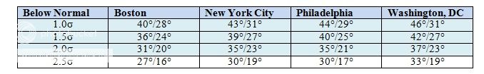
The ensemble guidance continues to point to an impressive cold shot during the 11/24-29 timeframe, with 1-2 standard deviation anomalies in parts of the East in the 11/26-28 period. Such anomalies would mean that Washington, DC would see at least its first freeze of the season and possibly low in the 20s. The following chart shows highs and lows that are 0.5σ to 2.5σ below normal (11/20-30 period under the 1981-2010 baseline):
In the medium-term, the Arctic Oscillation (AO), which has been strongly positive through much of this month is forecast to go negative. The big question concerns whether the blocking will prove temporary or perhaps more sustained. The outcome would have a large influence on December. Right now, the ensemble guidance is split into two camps so to speak:

That leaves December somewhat up for question. The partial teleconnection cases have argued consistently for a mild December across much of the CONUS and cold in parts of Canada. For the first time, the rolled-forward cases suggest a smaller area of warm anomalies. That is the result of factoring in the cluster of ensembles pointing to a possible sustained period of blocking. Excluding those ensemble members, the consistent idea from earlier guidance remains intact. Odds may still favor that former situation.
In the meantime, the CFSv2 has again flip-flopped. It is again showing a milder outcome from much of the CONUS and is quite consistent with most of the earlier partial teleconnection cases:

Finally, some mention of last night’s GFS “craziness” is in order. The 11/18 6z GFS was very cold in the long range, but the 0z run featured an extreme early-season cold shot following an early-season snowstorm. At 372 hours, the 2 meter temperatures were forecast as follows on that run:
Boston: -7.6°C (18°F)
New York City: -11.0°C (12°F)
Philadelphia: -14.7°C (6°F) — This would be a record low temperature and the coldest so early in the season
Washington, DC: -10.7°C (13°F)
Such Arctic outbreaks have often occurred in Decembers that proved colder than normal in the affected region and during winters that also proved colder than normal. There were some exceptions with either warmer Decembers (1965, 1967) or warmer winters (1989-90). There were a number of winters that were notable for cold and/or snow (1958-59, 1966-67, 1976-77, 2002-03). In short, while the GFS likely was overdone with the cold shot, that development, if it unfolds, could provide some insight into the upcoming winter.
******************************************************************************************************************************************
Posted Sunday, November 17 @ 11:18 PM
As has been noted throughout this thread, I use partial teleconnection cases (excluding ENSO) to look at trends. There continues to be little change in the overall consistency of taking those cases and rolling them forward to December. Looking upstream to Canada, they paint a picture that is quite similar to the 10-day ensemble mean anomalies posted by Environment Canada. Subsequently, the area of cold anomalies would retreat westward once those cases are rolled forward for December.

In the meantime, the CFSv2 had flipped back to cold in the eastern CONUS for December. The recent poor run-to-run continuity on that guidance suggests a lot of uncertainty. In a few more days, that ensemble system will be reaching a timeframe where it has demonstrated some skill. It will be interesting to see where things stand at that time.
******************************************************************************************************************************************
Posted Sunday, November 17 @ 09:24 AM
AO begins its decline…
This morning, the AO stood at +3.138. It is forecast to go negative down the road. At the same time, both the ensembles suggest a strong shot of cold for the closing 10 days of November with readings of perhaps 1.5 standard deviations below normal in areas. The timing of the arrival of the cold air could make a difference as to whether there is a small to perhaps even moderate snowfall in parts of the East late next week.
Prior to that, an impressive severe weather outbreak centered over the Ohio Valley is likely to unfold today and then spread eastward overnight.
The key to December’s outcome is whether the blocking that is currently forecast to develop becomes sustained. Odds still are against that outcome, but fairly low run-to-run consistency of the long-range guidance suggests higher than usual uncertainty. The partial teleconnection cases still argue for a warm December in much of the CONUS and cold in parts of Europe.
******************************************************************************************************************************************
Posted Saturday, November 16 @ 09:24 AM
Brief morning thoughts…
1. AO: +4.317 (beats old daily record of +3.754 set in 1994) and is the 4th highest on record for November. The AO is forecast to go negative in the long range. Big question: Will that mark a temporary departure from the predominant winter pattern or a more persistent blocking regime? Odds still favor the former.
2. EPO looks to remain primarily neutral or negative through the rest of the month.
3. Partial daily teleconnection cases from today’s data rolled forward to December maintain anomaly ideas similar to those shown in Messages #57 and #73, both for Europe and North America.
4. The latest CFSv2 monthly took a step toward the above-referenced ideas for North America, but remain warm for Europe.
******************************************************************************************************************************************
Posted Friday, November 15 @ 10:06 PM
Today, the Arctic Oscillation stood at +4.287. That was the second highest figure on record for November 15. The daily record is 4.363, set in 1994. It is also the 4th highest figure on record for November and only the 7th November reading at or above +4.000. In contrast, the EPO was strongly negative.
The ENSO + teleconnection combination still suggests warmth in the CONUS for December and cold anomalies across a large section of Europe. Those themes are consistent with repeated daily analyses of the partial teleconnection cases (excluding ENSO).

The 11/15 0z run of the GFS ensembles (312 hours through 360 hours) hinted that the cold anomalies would be retreating toward the area outlined for the most notable cold anomalies on the above maps. The animation is below:

Often pattern changes are rushed on the guidance, so it remains quite plausible that November ends cold and December starts cold with a transition toward the milder pattern perhaps unfolding in the 12/5-10 timeframe. That idea continues to be supported in rolling forward the partial teleconnection cases. Nevertheless, at this time, uncertainty remains quite high. Should the more extreme blocking shown by some ensemble members develop and wind up being sustained, that development could increase odds of a colder outcome in North America to go along with the trend toward a colder outcome in a large part of Europe.
******************************************************************************************************************************************
Posted Thursday, 14 November 2013 @ 10:19 AM
Development of Blocking Increases on the Guidance…
If one takes a look at the images in the first message in this thread, one finds a much more pronounced blocking signal toward the end of the month. If one also examines the EPO forecast, the EPO is projected to be negative to strongly negative in the extended range. Does this mean a cold December might be in store for the eastern half of the U.S./eastern part of southern Canada and a warm one in parts of the western U.S.?
For me, it’s still too soon to tell. Several factors continue to argue against it:
1. The typical December temperature anomalies following a November with an AO of +0.5 or above (there are some atypical cases)
2. The forecast progression of the MJO
It should also be noted that the CFSv2 monthly forecast for December has just changed to a cold in the East/warm in the West idea. That idea is remarkably similar to the composite anomalies for the atypical November AO+ cases (maps posted in Message #38).
One other thing I do daily is to run partial cases based on the forecast teleconnection indices. These partial cases exclude ENSO, as I use them mainly for watching trends. The December idea that will be posted in the next 7-10 days will include ENSO, among other additional variables.
The partial cases from this morning’s guidance were: 1982, 1991, 1995, 1996, 2000, 2001, 2007, 2008, 2010, 2012
I took those cases and ran the maps for November, December, and also created maps for the November 1-12, 2013 period. I did this for North America and Europe. Those maps are below:
North America:

Europe:

******************************************************************************************************************************************
Posted Wednesday, 13 November 2013 @ 12:39 PM
In last evening’s message (#40), I noted that if one rolls forward the ENSO-Teleconnections cases, the colder pattern shown for the 11/22-30 timeframe eventually yields to a warmer one. That outcome would be consistent with the tendency for December to see warmer than normal readings in the East following a November with an AO of +0.5 or above. November 2013 is very likely to have a figure of +1.5 to +2.0 or above.
Another argument for the transitional period marked by swings between cold and warmth is the MJO. The MJO has recently moved from Phase 8 to Phase 1. It is forecast by a lot (but not all) of the guidance to be moving into Phase 2 or Phase 3 toward the end of November or early in December. Should the MJO progress through Phases 2 and 3, such a progression would be consistent with the development of warmth consistent with the typical outcome following a positive or strongly positive November AO.
The November-December-January composite temperature anomalies for the MJO are below:

It should be noted that there can be some exceptions, but the map gives an idea concerning the temperature anomalies related to the MJO’s phases.
All said, odds continue to suggest that December 2013 will probably wind up warmer than normal in the East and possibly a fairly extensive portion of the CONUS.
******************************************************************************************************************************************
Posted Wednesday, 13 November 2013 @ 12:14 AM
Brief evening update…
11/13/2013 0z run of the GFS was cold for the eastern U.S. in the extended range. That fits with the extended range of the earlier run of the GFS ensembles. It also matches up well with the objective analogs (based off the GFS ensembles) rolled forward to be centered on 11/26 and the temperature anomalies for the 11/22-30 period resulting from the combination of ENSO and the forecast teleconnection indices.
Unlike the patterns that preceded the atypical outcomes following a November AO of +0.50 or higher (Message #38), there is a large area of warmth present. The atypical cases saw the 11/20-30 period with widespread cold in the CONUS. Instead, the maps suggest that most of the cold would remain in Canada. That might imply that the cold shots are part of a transitional period, which would culminate in the more typical December cases. Indeed, if one rolls forward the ENSO-Teleconnection cases, the warmth does spread into the East afterward.
The following are the maps from the ENSO-teleconnections and objective analogs:

******************************************************************************************************************************************
Posted Tuesday, 12 November 2013 @ 10:26 AM
Today, the Arctic Oscillation was +3.302. That marks the 5th consecutive day on which the AO has been at or above +3.000. For the month, the AO is averaging +2.679. The November record is +2.470, which was set in 1978.
It appears very likely that the AO will average at least +1.500 to +2.000 for the month. For the AO to finish the month with a +1.500 average, it would need to average +0.714 per day for the remainder of November. For it to average +2.000 for the month, it would need to average +1.547 for the rest of November. To beat the 1978 record, it would need to average +2.332 for the rest of the month.
Since 1950, November has had 14 cases during which the AO averaged +0.500 or above for the month. 10/14 (71%) saw warmth focused in the East in December. There were four exceptions: 1975, 1977, 1993, and 2003. Frequently, one saw the December pattern beginning to evolve during the closing 10 days of November. There were exceptions. With a period of blocking becoming increasingly likely during the closing days of November, one will need to watch for an atypical December outcome following the AO+ November. I’ll post my December thoughts in this thread in the next 10-14 days.
For now, I’ve listed some charts showing the typical and atypical December cases. I’ve also included partial teleconnection and partial ENSO-teleconnection cases for the 11/20-30 period (1981-present, not the full 1950-present data). Those cases show an area of warmth displaced for what one sees with respect to the typical December cases, but not the kind of widespread cold one often sees during the atypical ones. For now, the early odds still seem to favor the more typical cases, but things have at least grown a little more interesting.

*******************************************************************************************************************************************
Posted Monday, 11 November 2013 @ 09:06 AM
This morning, the Arctic Oscillation (AO) Index stood at +3.716. That’s the highest reading since December 25, 2011 when the AO was +3.824. A number of ensemble members forecast the AO to peak at or above +4.000. The November montly record is +4.544, which was set on November 2, 1978. In the extended range, the MJO is forecast to be meandering through Phase 1, which may suggest a continuation of mild periods alternating with some cool shots. If so, the ridge in the West/trough in the East showing up on the ensembles for the extended range could be transient.
In the meantime, on a more wintry note, it does appear increasingly likely that Baltimore, Philadelphia and New York City and adjacent suburbs could see some snowflakes overnight into tomorrow morning with some coatings on grassy surfaces. Cities such as Cleveland and Pittsburgh might pick up a light accumulation of snow tonight.
********************************************************************************************************************
Posted Sunday, 10 November 2013 @ 01:01 AM
1. The CFSv2 forecasts the Arctic to become much warmer than normal for December and to remain that way through the winter, on average.
2. Recent winters have witnessed an abnormally warm Arctic region.
3. The Arctic is typically colder than normal during AO+ regimes. That the Arctic has suddenly warmed despite the AO’s rising to +3 is a potentially large “red flag.”
Below are the composite temperature anomalies for the Arctic region for all cases where the AO rose to +3 or above in the November 1-15 timeframe (1950-2012):

Hence, I believe the situation bears watching.