|
A Good Evening Everyone,
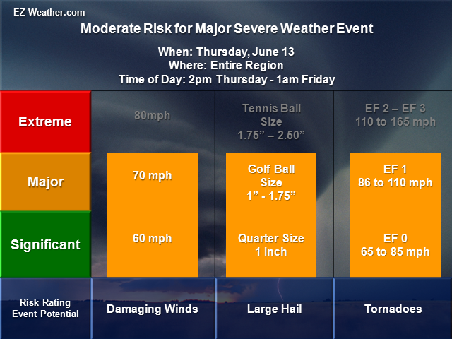
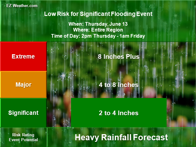
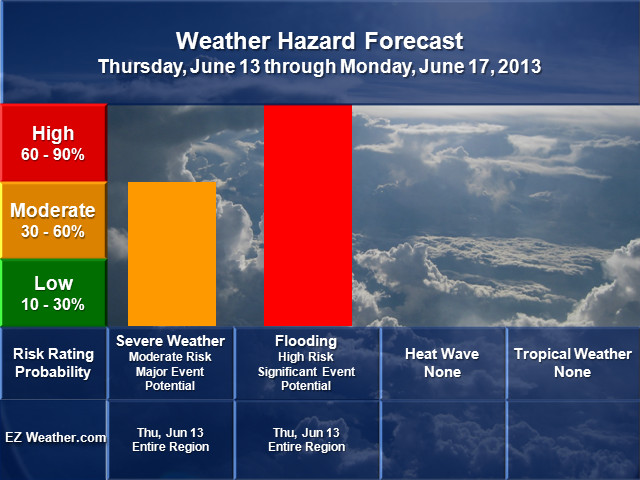
So, what do we know at this hour. The system is just starting to develop over the Midwest where there is a higher risk fro severe weather, which means damaging winds, large hail and tornadoes. In addition to those hazards, flooding is another major threat. Tonight will be a very active one for this area, which will spill over into Ohio, West Virginia and Western Pennsylvania late tonight before weakening. As this system heads east and the real crux of this forecast will be where the low tracks and its associated warm and cold front. If the low tracks further south, then that means a lesser risk of the severe weather across our region, but if the low tracks just enough north, then we face a widespread severe weather event. Right now, I still think this low will track just enough north, where most of the Philadelphia will face a major severe weather threat. So, my thoughts haven’t changed from yesterday. Aside from the severe weather threat, is the risk for flooding. Right now, I’m going with a high risk for significant flooding. Basically means, 2 to 4 inches could fall, which is what the NWS is thinking for tomorrow. They even note in their briefing, that some areas may receive high amounts, especially north of the Philadelphia Area. Given that we had a lot of rain over the weekend and on Monday, it won’t take much to see areas flood again. The other facet to this forecast will be how the low will deepen as it heads to the coast. Believe it or not, this system will develop into a Nor’easter and bring heavy rain and high winds for portions of Northeastern PA, NJ and up into eastern New England. All and all, a very active day. Finally, when does the worst hit.. The worst part of the event looks to be the afternoon versus the morning. The estimated time of the severe weather would be between 2 and 6pm. So, big impacts will be felt with PM rush hour and air travel. Expect quite a few delays later tomorrow as the weather goes down hill. With all this said, please plan accordingly keep checking back on the latest forecasts. Finally, I may have the 5 Day outlook updated, but obviously the focus is for tomorrow. The good news is that once we get past this event, the rest of the outlook appears to be quiet.
EZ Weather.com Philadelphia Area 5 Day Weather Hazard Outlook |
| Issued Wednesday Evening, June 10th at 7:00 PM EDT |
| X |
 |
| Zone Legend Reference (Click on the Zone Name to View Map)
|
| X |
|
Weather Hazard Forecast Details
Zone Legend Reference (Click on the Zone Name to View Map)
Disclaimer Information
|
| Latest Updates |