
Good Evening Everyone,
In this webcast series, we’ll be taking a look at the Weather Hazards Outlook for the Philadelphia Area. This outlook will be for Monday, April 15th through Friday, April 26th. There is a concern for the risk of severe thunderstorms that could impact the region late this upcoming week. Then the other concern will be the following week on a potential coastal storm. For all the details, check out the forecast and videos below.
Background: This webcast we’ll examine the prospects for any significant weather that could impact the region. In addition, I’ll be introducing a weather hazard risk rating forecast. This will help anyone involved with Skywarn, Emergency Management and anyone else that need to plan for significant hazardous weather ahead of time. The more we are aware of these severe weather threats, the more time we can plan for them.
Quick Video Guide
Part 1 – Short Range View – Taking a look at the upcoming 7 days
Part 2 – Excessive Rainfall and Thunderstorm Outlooks: Taking a look at the risk for Severe Thunderstorms and Flooding
Part 3 – Long Range View: Review of several Long Model Ensembles and Climate Prediction Center 6 to 10 and 8 to 14 Day Outlooks on Temperature and Precipitation
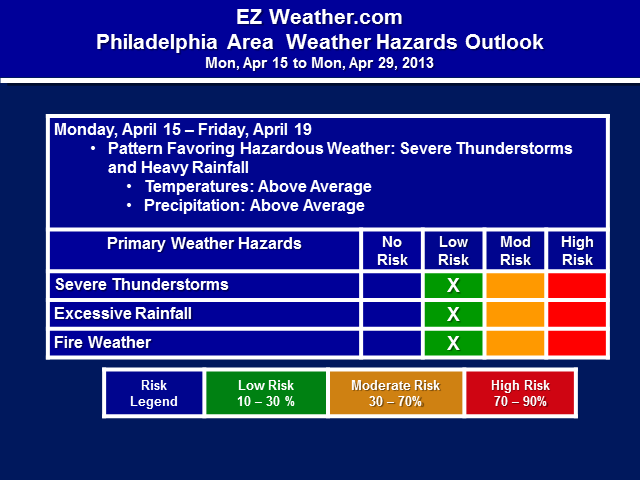
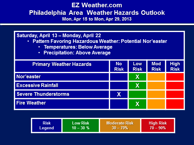
Part 4 – Risk Rating Forecast: Review of forecast with risk rating for weather hazards that could impact the area
Weather Hazard Risk Rating Forecasts
Note: Click on thumbnail for larger view
Check out these great websites for Weather Safety Resources. Click on any of the links below:
– FEMA
– NOAAWatch
– Office of Climate, Water, and Weather Services
– NWS Pamphlets