Good Evening Everyone,
Its that time again. Let’s take a look at January of 2012.
The first image shows what happen globally with regard to weather hazards. If you click on the image below, you will able to see it much larger.

Next, let’s take a look at the Significant Events for the month of January. Click to view larger view.

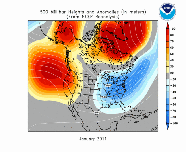
Next, let’s examine the 500mb Height and Anomaly map. When you look at the 500mb map, you can get a sense where ridges and troughs setup. The shades of red indicate ridging, while the shades of blue indicate troughing. Click on the map below to bring up January of 2011. Next let’s compare the two.
Let’s compare January of this year to last year. When you examine January of of this year to last year, there were major differences. This year significant height falls occurred over Alaska. What we see here is the Polar Vortex or a strong upper level low. This feature has been over Alaska not only this month, but as far back November. So, its been there for quite some time. Meanwhile, over the lower 48, ridging developed over Southwestern US and over the northeastern Atlantic, east of Greenland. This time last year, we had a totally different setup. Remembering back to last January of 2011, it was one that featured colder than average and significant wintry weather over the Eastern US. What really stood out was the amount of ridging that occured over the Western US, Alaska and Greenland. If you take a look at the telleconnections from last year, the Arctic Oscillation (AO) was very negative (i.e, values down to -3) and the North Atlantic Oscillation (NAO) was also negative (i.e, -2). For this year, the opposite has occurred, where the AO has been more on the positive cycle (i.e., +3 to +4) as well as the NAO (i.e +1 to +2). This year’s winter season was really absent compared to what Russia and Europe have seen. So, as you can see, lots of differences.
Next, let’s take as we move from January to February of last year. One of the things you’ll notice, the real wintry type pattern the Eastern US faced began to break down. Notice more shades of blue, which indicate height falls that began to develop over Greenland. If we take a look into the telleconnection indices as I mentioned above, the AO went from a very negative state to a strongly positive one with values getting into the +2 to 3 range. The NAO began to reach slightly positive. What you’ll see and will be discussed in the February Climate Review was that the Midwest would be the next major target for a massive blizzard. As you’ll see the pattern became quite favorable for significant snow and cold for the Central US. 
So, that pretty much will do it for January of 2012. For a complete report for this month, head over National Climate Data Center.

