
Good Monday Afternoon,
Welcome to another edition of the Weather Threat Assessment Forecast for the Philadelphia Area. We finally got some much needed rainfall across portions of the area. It wasn’t a lot of rainfall, but at this point, we’ll take it. The past several weeks have been warm and dry. Recently, the humidity has increased and even more like summer. Looks like that will end on Tuesday as a cold front moves through the region during the evening. We may even get some severe weather, which I’ll discuss below.
One item I wanted to address here is about our Spring season. The last several weeks have been very dry. Given the dry conditions, fire weather hazard has increased, so, keep an eye on NWS outlooks. The bulk of all the active weather has been over the Central US from Texas north to northern Plains. The Jet Stream has been consistently been bring several troughs into the Central US with strong weather systems. The persistent pattern, which has kept us dry has brought plenty of severe thunderstorms with strong tornadoes, damaging winds, large hail and heavy rainfall. Record breaking rainfall that has led to serious flooding over Texas continues. This time last year, that wasn’t the case for the folks out there. Amazing how the weather pattern can vary each year.
One final note, the current ENSO phase is a weak El Nino, but will get stronger as we get into the summer. What this may mean is that our summer could be cooler, but what about precipitation and the hurricane season. Well, typically, the Southern US gets hammered with a lot of precipitation and for the hurricane season, below average activity. So, for folks that live along the coast, that is great news, but remember it only takes on major hurricane to hit the US, so you have to always be ready for such a landfall. We’ll definitely have to see how this El Nino plays out the next several months.
Okay, thats it for some thoughts and now check out my updated outlook below for the next 2 weeks.
One final note, for folks that really get into tracking weather, I’ve now uploaded the model ensemble images. You’ll be able to check that for each forecast period in the Technical Weather.
For official outlooks, please check out the following links
– NWS Daily Weather Briefing
– NWS Mount Holly NJ Facebook
– NWS Mount Holly, NJ Twitter
Weather Threat Assessment Forecast
Monday, May 18th through Monday, June 1st
Southeastern Pennsylvania, Southern New Jersey, Northeast Maryland,
and Northern Delaware
Issued Sunday Evening, May 17th
5 Day Forecast Period
Monday, May 18th through Friday, May 22nd
Weather Threat Forecast Tables
(Click on the hyperlinks below to access the images below)
Note: Table Legend: Forecaster Confidence Level, Severity Event Index: Minor, Significant, Major, Extreme
Forecast Discussion
- Opening Remarks
- Weather pattern of late has been very dry and warm, but finally the area is getting some meaningful rainfall. For Monday, we’ll have a stationary front nearby to trigger some showers and thunderstorms. Right now, none will be severe, but any thunderstorm can put down some very heavy rainfall in a short period of time. Then on Tuesday, a cold font will move through the region late in the day. This cold front may cause a few thunderstorms to be severe. This type of severe weather event looks to be minor, which means only a few locations could be impacted.
- Temperatures will be above average early in the week and even be a few degrees below average by weeks end. The bulk of the precipitation will likely be early in the week.
- Technical Discussion
- The model ensembles favor an upper air pattern will feature a split flow over the Western US and some ridging over the Eastern US. A stationary front will be in place over the area on Monday, which may trigger some some showers and thunderstorms. Some of the storms may produce some gusty wind, heavy rainfall and frequent lightning. Then a cold front will approach the area on Tuesday and there maybe enough instability to trigger some severe thunderstorms. Right now, the type of severe weather event should be minor. Still, any thunderstorm that forms ahead of the cold front Tuesday afternoon could produce some gusty winds, small hail, heavy rainfall and frequent cloud to ground lighting.
- After Tuesday, ensembles really show a strong signal for high pressure to take shape over central Canada and into the Central US. Temperatures look to just above average early in this period and likely to be near average by the end of the week. Not much in the way of any precipitation expected.
- Model Ensemble Anomaly Forecast Maps (click on the hyperlinks to view the maps)
- Weather Threats
- There may be some excessive rainfall on Monday and Tuesday, but my confidence for it will be low. Right now I have it as a minor event. Checking with the Weather Prediction Center (WPC) precipitation outlook, shows totals about 0.50 inches. But given how humid things are, heavy rainfall of an inch can easily occur with any thunderstorm. The other threat is severe weather possible on Tuesday evening. The best instability appears more to the Northeastern US. Confidence on this event is medium for it being a minor event.
6 to 10 Day Forecast Period
Saturday, May 23rd through Wednesday, May 27th
Weather Threat Forecast Tables
(Click on the hyperlinks below to access the images below)
Note: Table Legend: Forecaster Confidence Level, Severity Event Index: Minor, Significant, Major, Extreme
Forecast Discussion
- Opening Remarks
- This period looks to be a uneventful. Temperatures and precipitation will be below average.
- Technical Discussion
- The model ensembles still favor an upper air pattern that will feature a split flow over the Western US and a trough over the Northeast US. Meanwhile, some ridging will start building over the Southeast US. The European Ensembles favor even stronger ridging to the north.
- For temperatures, all of the ensembles (ECWMF, GEFS, and Canadian) favor cooler than average temperatures. Precipitation is expected to be below average, which we could use the rain.
- Model Ensemble Anomaly Forecast Maps (click on the hyperlinks to view the maps)
- Weather Threats
- No major threats being forecasted.
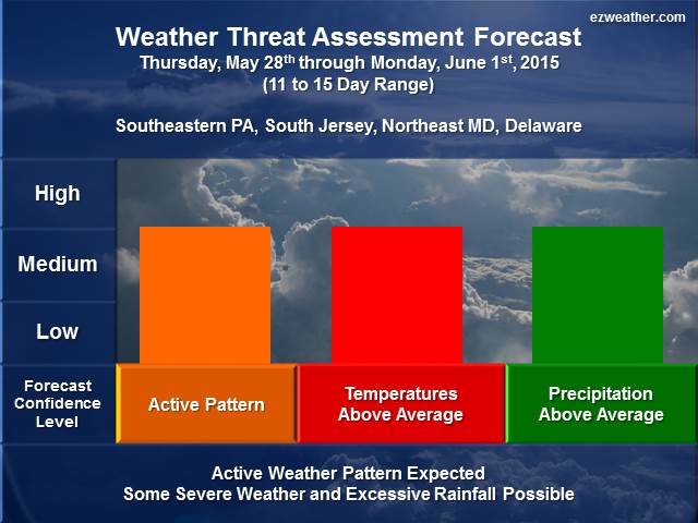
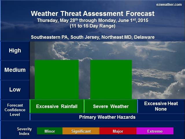
11 to 15 Day Period
Thursday, May 28th through Monday, June 1st
Weather Threat Forecast Tables
(Click on the hyperlinks below to access the images below)
Forecast Discussion
- Opening Remarks
- This period will feature a warmer period with a better chance for precipitation, which may mean an uptick in the chances for excessive rainfall and severe weather.
- Technical Discussion
- The model ensembles favor a some ridging over the western US and a trough over eastern Canada. The European ensemble favors more ridging across most of the country. Also, the model ensembles favor warmer than average temperatures for most of the country. Based on the average position of the Jet Stream, this could mean active period. In fact, the GEFS and the Canadian (GEPS) do show above average precipitation possible over the Central and Eastern US, which includes our region.
- Model Ensemble Anomaly Forecast Maps (click on the hyperlinks to view the maps)
- Weather Threats
- For this period, I’m forecasting some severe weather and even excessive rainfall, but confidence level is low. In terms of the Severity Index, right now I think it will be minor but hat will be subject to change. This period may be where the weather pattern is more favorable for precipitation chances, which could mean a better chance for severe weather and excessive rainfall. One thing to keep in mind, this spring season has been one where the region has not gotten a lot of rainfall. So, even though the model ensembles show increased rain chances, may have to take this into account for future forecasts.
X
************************************************************************************************************************************************
Background Information
- I am very excited to provide a new forecast product for the Philadelphia Area, which includes Southeastern Pennsylvania, South Jersey, northeastern Maryland, and Delaware. In here will be a new experimental product that I’ve produced for the Philadelphia Area.
- Right now, I like to issue this product once a week, especially on Sundays. If time permits, I’ll issue a new forecast during the week.
- This forecast will aide pretty much everyone from Public, Emergency Management, SKYWARN, and RACES. The idea is to provide everyone with a forecast that gives them the needed lead time to prepare for significant hazardous.
- Finally, below is further background on my forecast tables and geographic locations
- Table Legend
- Forecaster Confidence Level
- Severity Event Index: Minor, Significant, Major, Extreme
- Forecast Geographic Locations
- Southeast Pennsylvania: Chester, Montgomery, Bucks, Delaware, and Philadelphia
- South Jersey: Burlington, Ocean, Camden, Gloucester, Salem, Cumberland, Atlantic, Cape May
- Northeastern Maryland: Cecil, Kent, Queen Anne’s, Caroline, and Talbot
- Delaware: New Castle, Kent, and Sussex
- Table Legend