
Good Evening Everyone,
Very excited to back into some weather forecasting. So, I’m going to be expanding this forecast package that will include the Philadelphia. This forecast will now include Southeastern PA, Southern NJ, northeast Maryland and Delaware. As I mentioned a while back, this is an experimental forecast thats geared toward Threat Assessments. The goal of this forecast is to identify any hazardous weather threats ahead of time, that needed lead time that allows everyone to prepare for them. So, anyone involved in Emergency Management, SKYWARN, RACES and anyone else, this product will help you get that much needed lead time. The more we know about a certain weather pattern that may deliver major weather threats to the region, we can then allow ourselves more time to prepare and plan for them. One more point, this forecast is experimental, so I do recommend everyone to check out the official outlooks. I’ve added several links everyone can check from a national perspective to our area.
For official outlooks, please check out the following links
– NWS Daily Weather Briefing
– NWS Mount Holly NJ Facebook
– NWS Mount Holly, NJ Twitter
Weather Threat Assessment Forecast
Monday, April 13th through Monday, April 27th
Issued: Sunday Evening, April 12th
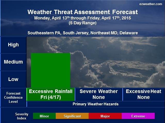
5 Day Period (Monday, April 13th through Friday, April 17th)
Note: Click on thumbnail image above to view in full. Also, for further details on table legends and forecast geographic location references, scroll down to the bottom of this blog entry under “Background Information”.
Weather Discussion
- Opening Remarks
- This week is looking to be on the quiet side. The one item we’ll need to monitor will be a cold approaching the area by Friday. The setup may include some heavy rainfall, which may cause some flooding.
- Sensible Weather
- In terms of the big picture upper air pattern, it favors ridging aloft over the Eastern US. High pressure will dominate the area on Monday, but moves away as a cold front approaches the region on Tuesday. Nothing major is expected the cold front. Then another high pressure system moves in for Wednesday and Thursday. There will be a cold front that will cross the region on Tuesday, but nothing major expected. Late in the week, we’ll need to keep an eye on the next cold front that moves into the area on Friday and Saturday. Ahead of the front, there maybe some heavy rainfall with it. The key will be how fast the front moves across the region. The slower the movement, the higher the chance for some heavier rainfall. Looks like a situation where high pressure off shore may slow down the front before it exits the coast next weekend. National Weather Service has mentioned this in their discussion last night about the heavy rain threat, so its something to keep an eye on.
- Weather Threats
- The only weather threat for this period will be on Friday where Excessive Rainfall is possible. Right now, I’ll note this as a possible threat with my confidence being medium. I don’t think this weather threat looks to be major at this time and isolated locations may deal with flooding.
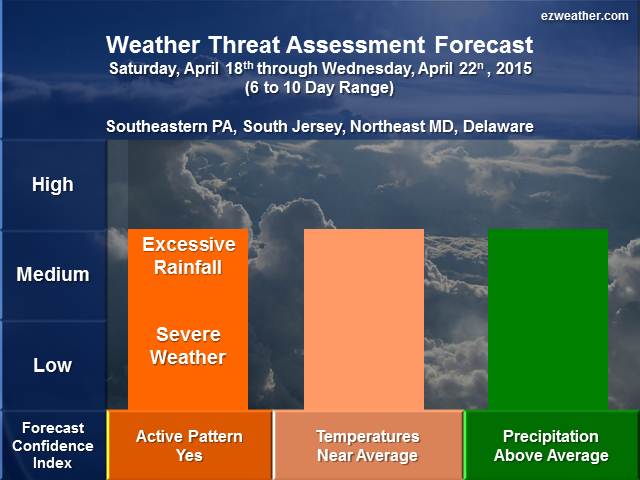
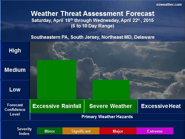
6 to 10 Day Period (Saturday, April 18th through Wednesday, April 22nd)
Note: Click on thumbnail image above to view in full. Also, for further details on table legends and forecast geographic location references, scroll down to the bottom of this blog entry under “Background Information”.
Weather Discussion
- Opening Remarks
- An unsettled pattern is likely for this period. Temperatures are expected to be close to average with on and off chances for precipitation.
- Sensible Weather
- The upper air pattern will favor a trough over the Central US, which will head east and be over our area as we get into the 11 to 15 day range. Temperatures will be near average, while precipitation be above average.
- Weather Threats
- The two main weather threats we need to monitor will be excessive rainfall and severe weather. The position of the trough or dip in the jet stream is the key and it looks to be setting up over the central US. Now based on that position, systems will pass to our west. So, the opportunity may exist for some severe weather and excessive rainfall. I’m favoring excessive rainfall versus severe weather in this time frame.
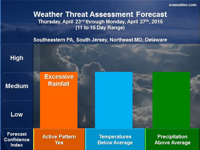
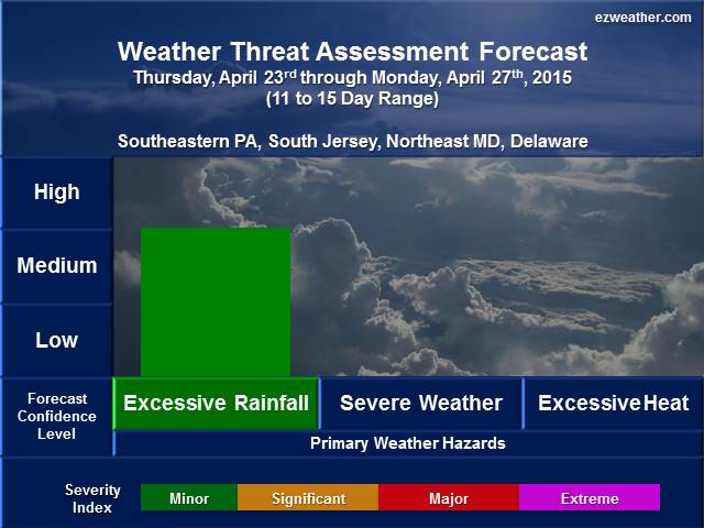
8 to 14 Day Period (Thursday, April 23rd through Monday, April 27th)
Note: Click on thumbnail image above to view in full. Also, for further details on table legends and forecast geographic location references, scroll down to the bottom of this blog entry under “Background Information”.
Weather Discussion
-
- Opening Remarks
- A continuation of unsettled weather pattern is likely for this period. Temperatures are expected to be cooler than average and precipitation still looks to be above average. Overall, doesn’t look like a mild period, but just unsettled.
- Sensible Weather
- The upper air pattern will favor a trough over the Eastern US. While the trough settles over the Eastern US, ridging setup over the Western US. Temperatures are expected to be below average, while precipitation is above average.
- Weather Threats
- The main weather threat we may have to contend with is excessive rainfall. Right now, I’m moderately confident on the excessive rainfall, but not expected to be major. With regard to any severe weather threats, not expecting much based on where the trough will setup, which will be right over area area.
- The main weather threat we may have to contend with is excessive rainfall. Right now, I’m moderately confident on the excessive rainfall, but not expected to be major. With regard to any severe weather threats, not expecting much based on where the trough will setup, which will be right over area area.
- Opening Remarks
X
************************************************************************************************************************************************
Background Information
- I am very excited to provide a new forecast product for the Philadelphia Area, which includes Southeastern Pennsylvania, South Jersey, northeastern Maryland, and Delaware. In here will be a new experimental product that I’ve produced for the Philadelphia Area.
- Right now, I like to issue this product once a week, especially on Sundays. If time permits, I’ll issue a new forecast during the week.
- This forecast will aide pretty much everyone from Public, Emergency Management, SKYWARN, and RACES. The idea is to provide everyone with a forecast that gives them the needed lead time to prepare for significant hazardous.
- Finally, below is further background on my forecast tables and geographic locations
- Table Legend
- Forecaster Confidence
- Severity Event Index: Minor, Significant, Major, Extreme
- Forecast Geographic Locations
- Southeast Pennsylvania: Chester, Montgomery, Bucks, Delaware, and Philadelphia
- South Jersey: Burlington, Ocean, Camden, Gloucester, Salem, Cumberland, Atlantic, Cape May
- Northeastern Maryland: Cecil, Kent, Queen Anne’s, Caroline, and Talbot
- Delaware: New Castle, Kent, and Sussex
- Table Legend